Pages

Saturday, December 31, 2011

CR2011: Huber and Yukness Ledges

The path along the Huber Ledges connects Wiwaxy Gap to Lake Oesa. Starting out, a first-timer would be uncertain if this trail actually makes it all the way through. From down at Lake O'Hara, you can't see it at all.
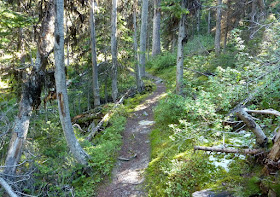
But it does. The route is often clear ...
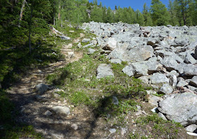
... but there are sometimes rocky parts where you must choose the best option for your length of leg, size of boot, sense of balance, etc. Keep an eye out for the alpine blazes so you don't get fooled by a false path in these locations.
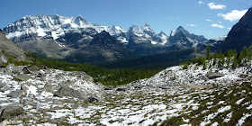
As you proceed on the Huber Ledges a chain of lakes comes into view. In this next picture note the gray field of boulders towards which the trail is heading; this is another spot where the alpine blazes are important. It's also the only place on the Huber Ledges where you can improvise a relief stop.
Looking more closely at the lakes,
Oesa is at top left. Then the water flows through Lefroy Lake and Lake Victoria; the shallow green water at far right, directly under the Yukness Ledges, is one of the Nymph Pools.

I took a closer, wider photo of Lake Oesa as we exited the boulder field. The relatively flat, stony shelf at right is a popular picnic stop, whether you arrive via the Huber Ledges, Yukness Ledges, or the Oesa trail that arrives directly from Lake O'Hara.
In the photo the lake doesn't look as large as it should. For scale, can you find the people enjoying the picnic grounds on the right? This next picture will zoom and point them out. If necessary, click to enlarge!
Joan and I enjoyed a sunny lunch with at least a dozen other hikers scattered around the shelf. Then we rambled to the far side to join the Yukness Ledges trail, which drops off the Oesa platform before it reaches the Yukness scree slope. Here, we look back to see other hikers making that descent. It's minor, but it requires a couple of alpine blazes to find the correct way.
The initial scree path has chunks of rock bigger than  stones but smaller than  boulders.
The trail soon arrives at a tilted and fracturing table-top. Weaving between the blocks, the alpine route reaches the edge of the highest level, and drops down, precipitously at first, and then more easily, to the lowest level. This picture was taken from our earlier viewpoint on the Huber Ledges. If you click to enlarge you can discern the trail hugging the far right of the ledge.
Here we look back towards Oesa from the table-top.
Other hikers pose for a photo near the edge.
This blaze marks the start of the clamber down to the lower levels of Yukness -- not the end of the road, which it otherwise resembles.
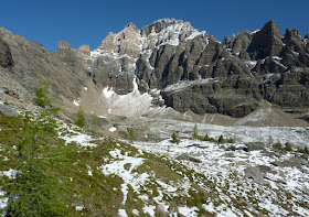
Once headed west the trail quickly enters a geological grove, shards fallen down from North Yukness Peak. Fortunately for us they don't break loose often, at least on a human time scale.
There is just enough climbing and descending to keep the hiker warmed up.
There are wonderful views from Yukness Ledges, many of which are variations on a theme. I'll present only one example, which looks straight along the length of Lake O'Hara. The zig-zag trail climbing from the lakeside, far right, is the direct route to Oesa from O'Hara. There are pale green rings of submerged avalanche debris next to the shore.
Eventually the route bends south as its works around the promontory, and now it is carrying us into the Opabin Plateau, but higher up than the east trail, visible between the trees below on the right.
The Yukness Ledges route ends at Hungabee Lake, where we were in the snow two days ago. But first there is another boulder field to thread through.
Then it's down the east trail one more time to Lake O'Hara. After we return to the cabin and clean up, we head to the cheerful-looking lodge for dinner.
Sadly, the next morning we must depart. We have a full day of driving to begin the last segment of our trip, and a completely opposite one to what we have accomplished so far. We're changing from the mountains to the plains, and from chills to dry heat. We're heading to Brooks, about 230 miles to the east, where we'll stay while visiting Dinosaur Provincial Park. But that's a subject for the next post.

Here is a farewell photo of Lake O'Hara and Cathedral Mountain, taken while waiting for the morning bus.
As soon as you leave O'Hara, you're planning how and when to return.

Friday, December 30, 2011

CR2011: Climbing to Wiwaxy Gap

The next day was another sunny one. This meant that between yesterday and today most of the snow should be gone from the alpine routes. We decided it was a good day to hike a favorite route, up to Wiwaxy Gap and then along the Huber and Yukness ledges.

The trail to Wiwaxy splits off the lakeside trail close to the north end. This photo is taken towards the north end of Lake O'Hara, not long after leaving our cabin.
There's a sign where the Wiwaxy trail begins. Note the two different images used for alpine routes -- Wiwaxy Gap is walkable, if steep, while Abbot Pass, at bottom, requires climbing.
And the Wiwaxy route goes up from the very first step. It's steeper than it looks; we'll see a later section in profile.
The path quickly leaves the wooded section seen above and starts a series of rapid switchbacks along the side of a gully, out in the sun. You can see some hikers ahead of us, upper center, in this image.
Here we have paused partway up the gully to look back at the lake. The people in the previous photo are now behind us; we leapfrogged each other several times this morning. There are many reasons to pause besides catching your breath, including taking off the jackets or gloves that seemed necessary down by the lake. At this point your inner furnace is  running at 100%.
Near the top of the gully the trail becomes more gentle and heads into woods on the right. The model in the next photo, with the blue shirt and yellow daypack, is Joan.
In this stretch there is a grand old tree, a grandfather or grandmother tree, eking a living from a precarious site and rocky soil. We touch his bark and greet him each time we pass.
The trail then arrives at rock ledges, where hikers slow down and watch their footing. There are a couple of switchbacks which require keeping an eye out for the alpine blazes.
Although the path may be narrow, it's not always steep. Just most of the time.
I was able to persuade Joan to pose for the next picture without much difficulty. The green carpet in the center, higher up on the far side of the lake, begins the Opabin Plateau.
In rocky country, the alpine trail blazes are necessary to avoid false turns, and to take the correct ones.
The Wiwaxy trail is varied. Now the rock ledges are left behind and the trees thin as we emerge into more open slopes.
The path steepens and becomes looser under foot, and all shade is lost.
There are, inevitably, more switchbacks.
Finally we are getting near the top.
Now I can show you a trail profile, with a picture I took later from the Yukness Ledges. Click to enlarge and watch the trail rise from the lower left corner to upper right.
Finally I was at the top, 2532 meters or about 8,300' above sea level. As soon as I stepped into the windy pass I rolled my shirtsleeves back down.
I couldn't resist taking a video from the gap, even if my camera lens was a bit dusty. I scanned about 330° of some of the most gorgeous scenes in the world.


It was too early for lunch. So it was time to walk along the Huber Ledges to Lake Oesa -- in the next post.

Monday, December 26, 2011

CR2011: A Lake Trio: Linda, Cathedral, and Monica Lake

This day began with full sunshine and stayed that way. Our goal today, our top-of-the-list for this stay at Lake O'Hara, was Monica Lake. Monica lies in a small bowl between Cathedral Prospect and Cathedral Mountain, and although we'd been to the prospect once before, and the lakes along the route more than once, we'd never made it all the way to Monica, just under 5 miles one way.

The first stretch, whether you take the Morning Glory Lakes trail or the campground trail, isn't interesting after the first visit. It's a walk in the woods that chews up time before you reach the good stuff. We took advantage of the morning bus option: join the guests departing that morning on the lodge bus, informing the management the evening before of your plans. Remind the bus driver to drop you off at the Linda Lake junction, and you've saved a tedious mile.

Here's a picture of the trail heading up from the Linda Lake junction.
The air was frosty and patches of snow had survived the night, more so as we gained altitude. Here Joan crosses the footbridge across Morning Glory Creek, partway to Linda Lake. The sun is just starting to spill over into the basin, while Odaray Mountain (about 10,300') is brilliant.
Once you arrive at Linda Lake, there appear to be a swarm of choices, although many begin by heading the same way.
We passed by the north shore of Linda Lake. There's more to Linda than is apparent in this picture.
Our trail wound on to Cathedral Lake. In this photo we have almost reached it -- click to enlarge.
The near side of the lake still has a thin skin of ice on it. The peaks that rim this valley have nosed up over the trees.
The trail passes by the north end of the lake, and after a while the trail to Duchesney Basin and Last Larch Prospect splits off to the left as the Cathedral trail veers to the right and begins to climb. Shortly you are going directly uphill between a rock field and the trees.
As you climb higher there are more rocks and fewer trees, and the mountains grow closer.
At the edge of the tree line the route turns sharply to the right and rises more gently. You are traversing the platform that lies before Consummation Peak, Goat Peak, and Cathedral Mountain.
The view towards Cathedral Mountain opens up.
There are many stopping places with astonishing vistas along this stretch, but we continued on until Monica Lake popped into view.
Here we sat in the sunshine and ate our lunch. We had occasional company.
After lunch we strolled along the prospect, binoculars in hand, taking many pictures.
The lake in the far distance, at the foot of the mountains, is Lake O'Hara. You can see we have traveled some distance from the lodge! The next image looks into both the O'Hara and Duchesnay valleys. Ordaray Mountain is a shadowed sentinel at the corner of the two.
We retraced our steps and began to descend. The sunlight now reflected off the Cathedral Lakes, left, and one of the Odaray Lakes, right, just under the mountain. We saw many mini-avalanches on the face of Odaray as pockets of snow would loosen and fall with a soft rumble.
Now the rock field must be negotiated downhill. Thank goodness for walking sticks!
Our return leg followed Linda Lake's south, not north, shore.
The rock pile you see above held at least one guardian pika.
With the afternoon light the view north was spectacular.
From Linda Lake we descended a moraine, through woods and along widely spaced switchbacks, reaching the Morning Glory Lakes. I have no photo of Morning Glory, but here is an overview of Cathedral, Linda, and Morning Glory lakes on the edge of Odaray's shadow.

View Larger Map
Then we began the long final two miles to Lake O'Hara. The first section of the trail gained about 500 feet, and then it set to wiggling through the forest.
With some relief we reached the near end of the Alpine Meadow, and its small pool. At the far side are the buildings of the Elizabeth Parker Hut, administered by the Alpine Club of Canada.
Now we were less than half a mile from our cabin. We were pleased to have added Monica Lake to our tally on such a fine day.