Saturday (Sept. 16) was our day to hike the Iceline along with a bevy of weekenders and other hikers. Joan and I had hiked it twice in earlier years, but not documented in this blog. The initial section of our first Iceline hike was in rain, and then much of the time passed in a dense fog that thinned into nothingness by the time we reached our turnaround point. Glaciers? Valleys? It was all a slow reveal that time, a moonscape, an atmosphere of mystery, one hike we'll never forget. Today we were happy to have plenty of sunshine. Joan and I had pre-ordered trail lunches at Cathedral Mountain Lodge for 7:15, but after we finished breakfast at 7:25, the lunches weren't ready; the "breakfast chef was busy." They finally came out at 7:40. A warning: Joan ordered the vegetarian sandwich, but we later discovered that it was just the choice-of-meat sandwich without the meat, mostly bread and garnishes. We were very glad to have a hefty chocolate bar! We drove our rental car up the seasonal highway to Takakkaw Falls. That road includes two tight switchbacks that preclude long vehicles or those with trailers from making the trip; RVs of modest dimensions can manage it if they're willing to drive in reverse between the switchbacks.
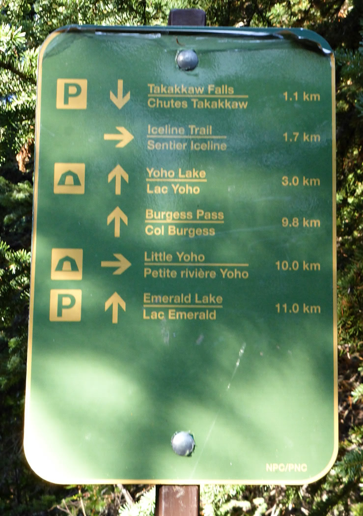
At the parking area Joan and I stepped out into bitter cold. All the signs were frost-covered and the privy seats had a coating of ice, which was quite a shock. We didn't linger to view the falls, but marched briskly towards and across the road and past the Whisky Jack hostel. We would be climbing the side of the valley opposite the falls.
Despite gloves my fingers tingled with the cold and I continually flexed them, even while holding my hiking poles, to warm the muscles and to see if they still obeyed me. I wondered if I had made a mistake by bringing my medium-weight gloves instead of the cumbersome but warmer ones. Fortunately the trail soon began to climb, with frequent switchbacks and steep segments, and the exercise brought my fingers back from the brink of numbness. There were several trail intersections,
but the Iceline was always the right-hand choice.
The trail climbed to the edge of the forested zone, and we were surrounded by mixed vegetation and rocks.
Another trail entered from the left ...
which could carry traffic to or from Yoho Lake or Emerald Lake.
Joan and I headed north, walking deliberately up a rocky trail that rose relentlessly through the lower slopes towards the upper moraines.
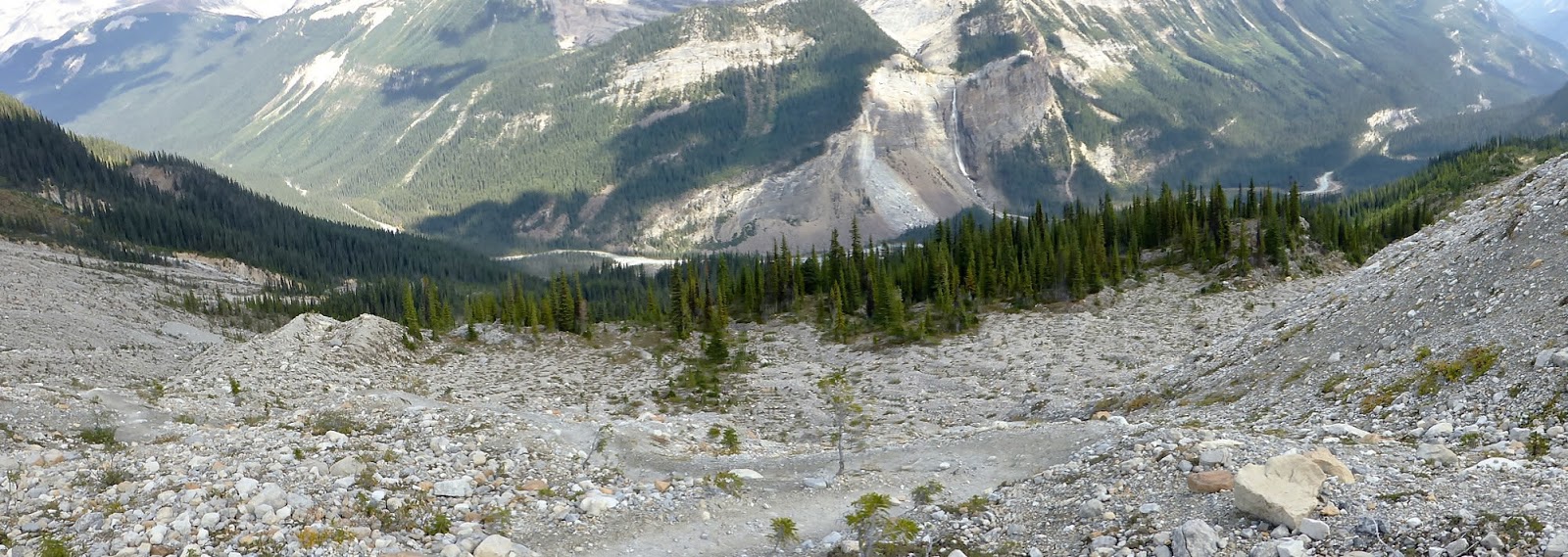
This was the view back to the valley of the Trans-Canada Highway, Canadian Pacific Railway, and Kicking Horse River.
Then we were high enough to see the glacier that feeds Takakkaw Falls, which is tucked into the shadows just right of center. Click on the image to enlarge.
The trail climbed some more, and Joan and I reached the first view of a glacier on this side of the valley.
Many hikers had come out on this sun-drenched Saturday, and most were faster than we were. A few were returning from an overnight at the Stanley Mitchell hut, but most were headed in our same direction. Some were on a day trip, a few were heading up to the hut, and there were adventurous souls who had no idea what was ahead. They had simply seen the trail and set out. In this picture hikers are climbing one of the many moraines left behind by the retreating glaciers. Note the switchback, the lower hikers are headed to the left and the higher ones are headed to the right.
This shot looks back the way we've come. Note the exposed rock slabs. In places they glistened so much that they looked like flooded rice paddies.
Did I mention that most hikers were faster than we were? In the original, full-size version of this photo I can identify 17 hikers; in the smaller web version it might be tough to do! Fourteen or fifteen, perhaps?
Many photographs were taken today.
Glacial remnants and melt pools.
Joan and I crested the final moraine before the Celeste Lake cutoff and called it our turnaround point, having lunched shortly before. If you prefer a loop, the trail past Celeste Lake descends into the valley, and it's a flat (boring) walk back to the parking area. We much preferred to stay up here with the views, returning the way we had come.
Mr. Frumble concurred.
The sun had ambled over to its afternoon post, changing the light for photos on our way back.
Hikers peeked over the edge.
Joan and I had time to socialize with various people on our way back. One fellow was visiting and YouTube-ing his visits to 26 national parks in the U.S. and Canada since college graduation. A woman with a friendly dog had worked for Parks Canada until she retired, and now works in the post office in Golden. At one point we could see all the way down to the river.
A good view to a lower ridge.
Joan and I descended into the woods again.
Takakkaw Falls was now fully illuminated.
Flat, slippery pebbles and small stones embedded in mud gave us some trouble in the last mile of switchbacks. Our feet skidded more than once, but we didn't take a tumble. That's another reason for hiking poles! It seemed to take forever to our tired feet, but we neared the end of the Iceline.
We lingered for several minutes at a viewing area for the falls. With binoculars we could see two people above the top of the falls -- how did they get there? (Rock climbing is not for us!)
There was a hint of a rainbow near the bottom. On the drive back to the lodge we saw an RV doing the backward drive on the middle switchback. They managed, although their cautious pace backed up traffic for a few minutes. Joan and I were pleased to have visited the Iceline again, even though her knee and my feet had neared their limit. I'm sure we'll do the Iceline again in a few years. The views are that good. Tomorrow will be a transit day to Kananaskis Country, with a hike to Baldy Pass.
No comments:
Post a Comment
Comments may not appear immediately as they are moderated by the author to eliminate spam.


No comments:
Post a Comment
Comments may not appear immediately as they are moderated by the author to eliminate spam.