Wednesday, April 26, 2017

CR2016: Down and Up to Grizzly Col

On the morning of August 4th the weather was good, but the prediction included a chance of thunderstorms in the afternoon.
Today's hike headed for Grizzly Col, the pass in the ridgeline just east-southeast of Copperstain Mountain.
This meant that we would descend ~300 meters, or 1000 feet, from the lodge before starting a 486 meter (1600 foot) climb up to 2386 meters, or 7830 feet.

At our first stop we inspected the Lodge's dam. Joan and I had encountered various electrical generation schemes at different "helicopter" lodges; Talus Lodge originally had a liquid-fueled generator that shut off at 9pm, but now has solar panels that minimize the use of the generator; a run-of-the-river micro-hydro generator at Mistaya Lodge, supplemented by solar panels, can handle lights and battery chargers but not hair dryers, just as at Talus; here at Purcell Lodge there is a diversion hydro generator that can handle one hair dryer with prior warning.

Halfway down the 1000 foot descent we visited the dam that supplies water to the hydro generator.
The dam provides a pool from which some of the water continues over the creek bed, and some of the water is piped to the generator at the bottom of the hill.

Screens keep debris out of the water fed to the pipe.
They periodically need cleaning.
But not today.
It's a long run of pipe down to the generator hut, and sections need replacement from time to time due to tree falls and other damage.
We had seen both spare and mangled pipe glistening in a small meadow from the top of Copperstain, and would again today.

The generator hut is small,
and the maintenance log unofficial.
Sarah adjusted the feed valve half a turn, but a few minutes after we departed she received a radio call from the Lodge that the power had dropped to 1 bar out of 8. The "hammer" that protects the generator from overload might have dropped. She ran back, restarted the system, exercised the valve wheel, and the power returned.

On reaching the bottom of the hill our group saw the site of the original owner/builder's yurts and a still-functioning outhouse. Then we started up the valley of Krummholz Creek, hoping to reach Grizzly Col despite the forecast thunderstorms. The early trail was in the woods, which thinned as we climbed; the trees spread out and the flowers and rocks became more alpine. The cloudiness increased.

In this photo we've already gained altitude. Back the way we've come the Lodge is near the top left, and halfway down the pipe "farm" is visible in a clearing (click on the image to enlarge).
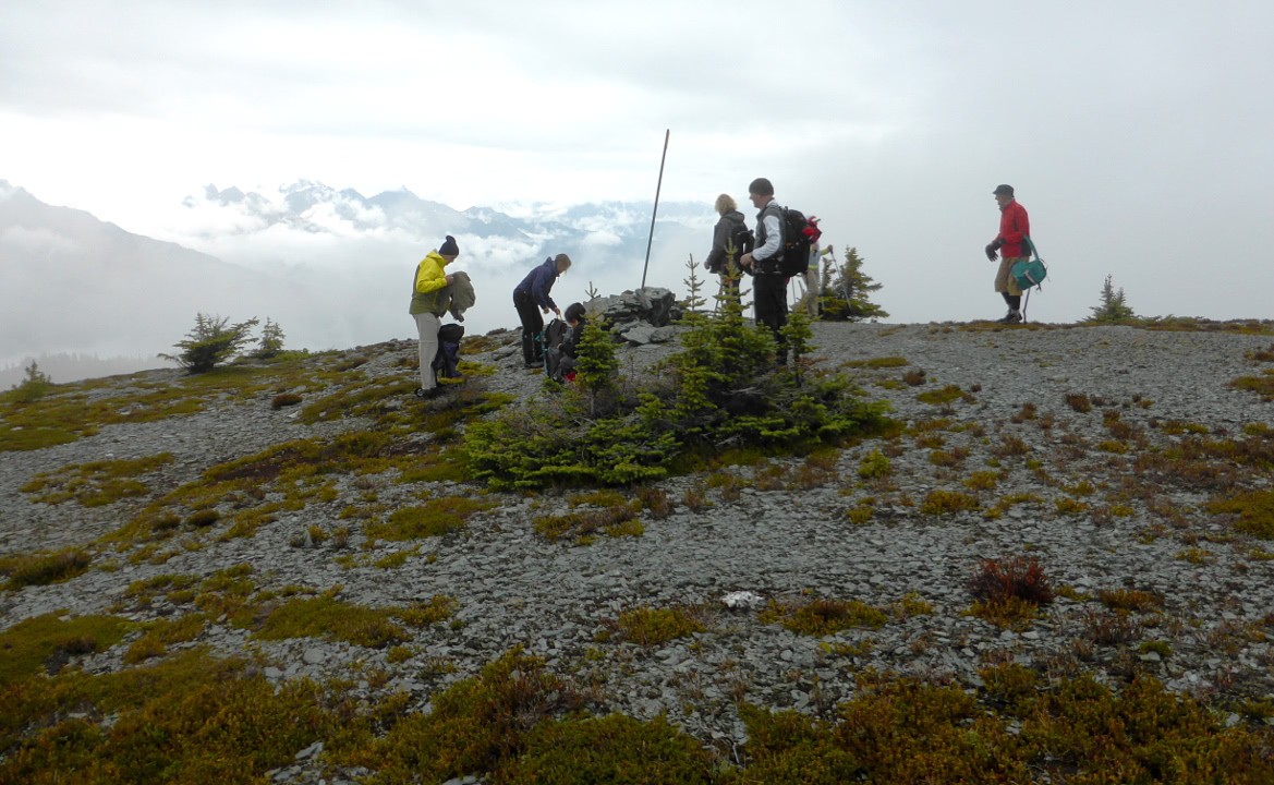
More hiking ensued, followed by our lunch break. The col was in sight ahead, but it'll still take some effort to get there. Kristin and Sarah were keeping a wary eye on the sky.
Our group pushed on. After a cool-down and water break below the pass, Kristin said it was turn-around time, but if we wanted to "run up to the pass" we had ten minutes. Say no more.
We made it!
Up here the snow lingered on the north slopes and in shaded pockets. There was a hiker in the middle of this snowbank.
Looking south.
Two panoramas, the first looking from the northeast (at right) to the northwest.
Overlapped by this panorama looking from the northwest (right) to the southwest. The peak at right is Copperstain.

The descent back down to the valley was not as difficult as we had dreaded, and the rain held off. The climb back up to the Lodge was a slog and I suffered from end-of-the-hike letdown, but then there was surprise champagne in honor of Sandy & Kelli's 15th anniversary (observed) as we arrived at the lodge.

That evening it was time to pack. Tomorrow would require multiple helicopter flights to swap the guests and some of the staff, and exchange garbage for supplies. Joan and I volunteered to be on the first helicopter out.

Monday, April 24, 2017

CR2016: Bald Mountain Lookouts

August 3rd began cloudy, cool (4°C), and damp,
but the rain began to stop, and our group shoved off at 10am for a tour of lookout points on Bald Mountain; the meadows are on the gentle south slope of that mountain.

We dressed warmly and with rain gear. Our first stop, at an unnamed viewpoint, looked down into (Canada's) Glacier National Park.
A closer look.
Zooming in on Sir Donald, in the mist.
We proceeded a short distance to Tumbledown Point, where we paused and enjoyed a snack.
This young tree, twisted by the winds, clung to the mountainside.
Fog and clouds continued to blow up the valleys and along the ridge, revealing and obscuring the view. Some of our group decided to return to the lodge, and the rest began to work uphill, a warming activity, towards the high point of the Purcell Meadow. 

This photo looks back at a creek we crossed.
The whitebark pine in this region is endangered, facing multiple threats including white pine blister rust, mountain pine beetle, climate change, and fire exclusion/suppression.
We continued uphill until we simultaneously reached the National Park boundary, the edge of the meadow, and the summit of Bald Mountain.
We happily shed our gear and dove into lunch.
However, Barry had a mishap. Placed on the edge of a scenic but steep drop on the north side, his pack began slide down the mountain. He grabbed it in time, but his water bottle flew out of the pack and didn't stop until it hit the rocks below. This concerned him. He called on Sarah, our guide, to help.
Now what? Sarah?
Sarah calmly made her way down to the rubble field, and with Barry directing, found the errant water bottle. (Click on the image to enlarge). She spritely made her way back up, and handed the cracked bottle to Barry.
Sarah is the red dot right of center.
The skies began to brighten after lunch, and we wiggled and wandered through the flower-laden meadow on the way back to Purcell Lodge, rejoining the Copperstain trail we had hiked yesterday.
As we neared the lodge Mount Sir Donald became a weather vane.
Hors d'oeuvres were waiting for us when we arrived at the lodge, 3pm. Wonderful!

Tomorrow was to be another ambitious hike, to Grizzly Col.

Saturday, April 8, 2017

CR2016: To the Top of Copperstain

The next day, August 2nd, our group at Purcell Mountain Lodge tackled Copperstain Mountain, elevation 2608 meters (8,556'). Many hikers, especially those not staying at the lodge, first head up to Grizzly Col from the south and then follow the ridgeline west-northwest to the summit of Copperstain. Today our guides would take us a different way.

It was a promising morning, even before a hearty breakfast.
We set off at 9:30, heading northeast through the largest alpine meadow in North America. Due to the wet winter (snow depth up to 10 meters at the lodge) and late blooming, it was full of flowers.
The tall peak is Copperstain
We saw paintbrushes, heathers, asters, and mystery flowers.
 Joan and I saw silky phacelia here today, and nowhere else. The photographers went nuts.
Our guide Sara was keeping an eye on things.
What do you see?
We hiked down to the crease between the meadow and the flanks of Copperstain. Looking ahead, we could see we'd be hiking uphill soon. (Click on the image to enlarge.)
Up we started. After reaching the corner the trail  jogged to the right and we climbed up the ridgeline. On the far side a bowl with downed timbers unfolded.
We stopped for a rest and a snack, and contemplated the way ahead.
That peaks looks awfully high up.
As we trudged higher and higher the Selkirk Mountains heaved into view.
Wow!
Now the trail wove back and forth through shale.
At this level our group frequently saw pieces of slate with perfectly round hole(s) in them, the back side broken out as if the hole was caused by a bullet. It was another enduring mystery.

This was the view looking back to the ground we'd covered so far.
Joan and I reached the top in the middle of pack. Everyone made it up except Linda, who had always intended to accompany us just through the meadow because of a pulled hamstring. Our guides were able to check in with her by radio, even from the summit.
The panorama was spectacular in all directions. It's hard to believe that the Trans-Canada highway is tucked in at the foot of those mountains.
You can see how big the meadow is too.
Zooming in on Mount Sir Donald, the dirty areas from the recent rockfall were clear.
And then it was time to go down.
Heading back to the lower ridgeline.
As we rounded the corner to head south and down to the meadow, Joan paused in contemplation.
We weren't the first ones to the edge of the meadow, our rest and regrouping point.
A surprise awaited us back at the lodge: creek-cooled beer. I'm normally not a beer drinker, but it tasted pretty good after today's exertion.

The good weather held up throughout our hike, but it didn't last forever. There was thunder and then steady rain after 5:00. But our group was snug in the lodge, well fed and pleased with our success.