August 5th, Buchan Gulf, a fjord system of Baffin Island carved out by glaciers in ages past. Fog. Lots of fog. The morning light has a steely hue.
We waited more or less patiently, and the fog began to thin and lift.
The Explorer sailed deeper into the gulf, and the cliffs and glaciers of the fjord began to unveil.
Here's a closer look at one of the many glacial tongues lapping at the water.
Then narwhals showed up. These marine mammals, a toothed whale, are sometimes called the "unicorn of the sea" because of their tusk, which is a greatly elongated tooth. They shy away from humans, having been hunted by the Inuit in the past and under subsistence regulations today. Those photos of a pack of narwhal with tusks raised into the air? That happens only when they are concentrated in a small break in the ice. Normally they swim low in the water, tusk submerged.
We shadowed the narwhals for a while, but under the circumstances, this is the best photo I was able to take.
This fellow undoubtedly obtained a sharper, closer picture. I swear the lens is bigger than many backyard telescopes.
He needs one heck of a tripod.
Many of the glaciers here no longer reach the sea. But their meltwater does.
Looking back the way we had come, the view got better and better. And more impressive.
This glacier looks a mold taken of a dragon's tail. (I recently saw The Desolation of Smaug.)
A polar bear alert! Lunch is postponed while we watch this bear at rest, draped upon a rock. To understand how it takes a while to attune the eye to polar bears, consider my first photo of him; he's in the center. Click to enlarge. That's our usual dilemma: is it a white rock, or a polar bear? Where did the spotting scope go?
The ship creeps closer.
Eventually, the bear decides to move. Cameras click and whir.
The bear kept a steady rhythm: amble and pause, amble and pause. Here he pauses, and considers what manner of beast we might be.
After a delayed lunch we arrive at a glacial outwash to land and take walks. But first, a zodiac is lowered past our cabin window.
We go ashore in our waterproof boots and form into groups.
Joan and I are in one of two groups that are aiming to hike as far up the valley as we can in the time allotted. The ground near the stream is boggy, so we work our way along the hillsides.
The cliffs above us generate meltwater cascades every spring, leaving ridges of debris that force us up and down.
We continued towards the top of the gap, hoping to see a glacier, but the path kept curving on.
Even here, seemingly near the crest of the gap, the melt waters were rushing with vigor.
Near our turnaround point we spotted snow geese on the far side. They are the white spots in this photo.
Soon it was time to turn and make our way back to the beach, and a pulled-pork barbecue.
Here's equipment for two kinds of shooting. Fortunately, no polar bears were encountered while we were on foot.
The only way you can get here is by ship.
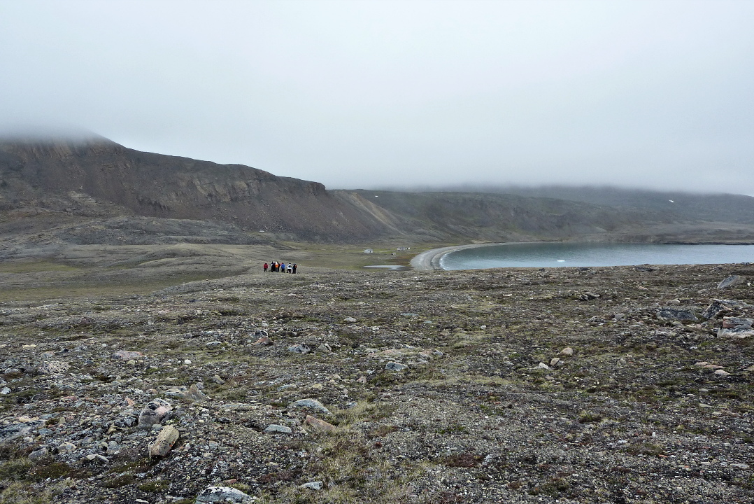
This would also be a good time to acknowledge our special expert on these waters, Captain Ray Jourdain, of Montreal. He joined us in Kangerlussuaq and his knowledge of the wildlife and ice conditions in Baffin Bay proved invaluable. In this photo, he's the gentleman everyone is clustered around.
The next day will take us to Isabella Bay and Arctic Harbor.
August 4th found us near the southeastern end of Devon Island, anchored off Dundas Harbor, a settlement founded in 1924 by the Canadian government with the intention to curb foreign whaling and otherwise maintain Canadian sovereignty in the far north. Nobody has lived here since 1951.
There were two smaller boats also anchored here.
Dundas Harbor is in red in the lower right of this map.
It was a wet landing, stepping from the zodiacs into a few inches of water on a shallow beach strewn with flat shingle rocks.
The guides all have a rifle against the possibility of encountering a polar bear, and in the upper left of the above photo a bear spotter is heading off for higher ground.
The morning was overcast and chilly. Our first stop was at a group of Inuit (Thule) dwelling foundations, with Vincent Butler (Vinnie) eagerly recounting the history of human habitation here. He's the guy at far left with a rifle.
Here Vinnie is showing us a walrus skull.
At water's edge artifacts and middens were abundant. Here Vinnie describes a stone tool.
Following along with us was Stevie Aluaqiaq, from Qikiqtarjuaq, Baffin Island. Stevie is a hunting guide and professional diver who works with Lindblad when they visit this part of the world. He will spot a polar bear before anybody else on the ship can.
In this photo Vinnie is showing is the exposed bones and shells from an eroding section of midden. Dog, walrus, polar bear, and whale bones are all here at this settlement site.
This foundation contains a number of large whale bones, such as vertebrae, which were probably used as structural elements. In summer, when skins were stretched over the foundation, whale ribs might be employed as well as valuable driftwood to support the skins.
After climbing a low rise we saw the distant, abandoned Dundas Harbor RCMP buildings, in the center of this photo (click to enlarge).
We approached the buildings in several different groups, to avoid mobbing each building and to maintain a good guest-guide ratio. Some groups had also taken a less roundabout route.
Down at the beach were scattered pieces of a beluga whale skeleton.
We arrived at the main building.
Three men were sent to this isolated location in August 1924, and their only communication with the outside world was a supply ship once a year. Before the three-year assignment was finished, one had committed suicide and one had died in a hunting accident. Their graves we shall see later.
There are two other buildings in Dundas Harbor, a storehouse and an outhouse.
We spent most of our time exploring the main building.
Some, including Jack, the ship's doctor, took advantage of the windows.
There isn't much remaining: rusting bed frames, bottles, batteries, newpapers, and graffiti.
Behind the buildings, on a slight rise, is the cemetery.
We approach it.
There are four headstones or graves here; I took a photo of three: the two RCMP constables, and the baby of a daughter of one of the Inuit special constables sent to Devon Island to help the Mounties. The fourth is of a Scottish whaler.
After everyone rejoined the Explorer we continued down the coast of Devon Island. Here, we see a glacier that has clearly been retreating.
Around 3:30 we were visited by a pod of four orcas. The orcas can swim much faster than our ship can sail, so they were free to leave at any time, but they played with us, diving under the ship to appear on the other side, racing ahead and then disappearing to reappear in another direction, and generally having a good time. There were two females, a calf, and one male (the one with a dorsal fin the size of a sail).
When they swam by the ship close to the surface, you could see their markings. Note not only the orca at bottom of this photo, but the one at the top. Click to enlarge.
More commonly I got a picture of their back.
Here, note the blow on the far left just emerging from the water; the orca began exhaling before the she breached the surface.
This afternoon also included two lectures, one being The Franklin Expedition: The Boys on Beechey, which was interrupted yesterday by wildlife spotting, and Life and Times of the Polar Bear. After dinner the classic black-and-white silent movie, Nanook of the North, was played.
The sun never went down, but by pulling the shade and blocking gaps with books and tissue boxes, Joan and I were able to darken our cabin enough for a comfortable sleep.
Overnight the Explorer edged westward, towards the area of the lost Franklin Expedition (1845), but ice began to clog the channel of Lancaster Sound, so we reversed course and spent August 3rd cruising off Devon Island, on the north side of the Sound.
Lancaster Sound is one of the Arctic's most biologically productive marine areas. Our first sighting began about 7:30, when the bridge spotted walrus on the ice. The Explorer crept along slowly, not disturbing the animals. Although we could chatter away on the bridge, especially to guide newcomers' focus towards the walrus, those outside on the bow communicated in whispers alongside the clickity-click of cameras in burst mode. With binoculars we were able to discern that it was a pair of walrus on the little chunk of ice.
At 8:15 I was able to take this picture.
When the camera zooms in, you can see that the walrus facing us has only one tusk (click on the photo to enlarge). Walrus use their tusks for foraging on the sea floor and to haul out onto the ice, so they are prone to damage.
This was a perfect wildlife spotting in the Lindblad tradition: excellent viewing for the guests, staff, and crew without disturbing the animals.
Captain Kreuss gradually backed the Explorer away from the walrus and we then began working our way through thicker ice.
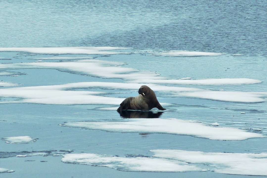
Roughly two hours later, we encountered another walrus, this time with two tusks.
The ice on which he rested was gradually sinking below the surface under the weight of his frame. Male Atlantic walrus average 2,000 pounds; the females about two-thirds of that.
This walrus saw an opportunity for lying on his back in the water.
About 1:00 pm we encountered an unconcerned bearded seal. I guess we didn't look like a polar bear. After three days of Thanksgiving turkey, I wonder if I don't look like the seal.
Half an hour later, we were visiting another walrus. At least, we thought it was only one walrus.
I missed the shot, but another guest captured the revelation that this was a mother and baby walrus.
Soon after they slid into the water and were gone from sight.
By now we were deep enough into Maxwell Bay to see the headlands. We were also a stone's throw from 75° N, and this would be the northernmost point of our journey.
The Explorer pivoted so that we could survey the action taking place on a broad sheet of ice between the bluffs of Maxwell Bay and the open water. We eagerly followed the progress of a mother polar bear and her two cubs, through binoculars. This is how it looked to my camera (click to enlarge).
Further to the left, a male was hunting along the edge of the ice. There were seals here, but they could easily see this guy coming.
He took a jump from one patch of ice to the next and missed. I didn't capture the leap, but here he is stretched out ignominiously afterwards.
We didn't leave the ship today, but we saw a lot. Lectures (The Franklin Expedition: The Boys on Beechy, The Evolution of the Arctic Submarine) were offered too, but frequently interrupted by wildlife announcements from the bridge.